History: New Madrid, County Missouri
New Madrid Earthquakes
This is a compilation from various sources, all referenced at the bottom
of the page.
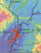
*The 400 terrified residents in the town of New Madrid (Missouri) were abruptly awakened by violent shaking and a tremendous roar. It was December 16, 1811, and a powerful earthquake had just struck. This was the first of three magnitude-8 earthquakes and thousands of aftershocks to rock the region that winter. Severe shaking accompanied the powerful New Madrid earthquakes that struck during the winter of 1811-1812. By winter's end, few houses within 250 miles of the Mississippi River town of New Madrid (Missouri) remained undamaged*
Survivors reported that the earthquakes caused cracks to open in the earth's surface, the ground to roll in visible waves, and large areas of land to sink or rise. The crew of the New Orleans (the first steamboat on the Mississippi, which was on her maiden voyage) reported mooring to an island only to awake in the morning and find that the island had disappeared below the waters of the Mississippi River. Damage was reported as far away as Charleston, South Carolina, and Washington, D.C.
The new Madrid Earthquake caused wide spread damage, extending north to Saint Louis, eastward though Kentucky to present day West Virginia and south and westward into Arkansas. The tremors were felt as far east as Philadelphia, where it is reported that church bells ran. For days before the first quake, animals fled the areas that would be effected. Passenger pigeons, in great flocks flew southward, deer and other animals attempted to swim the Ohio River. there would be a total of five earthquakes of 8.0 magnitude or higher from December 16, 1811 through February 7, 1812.
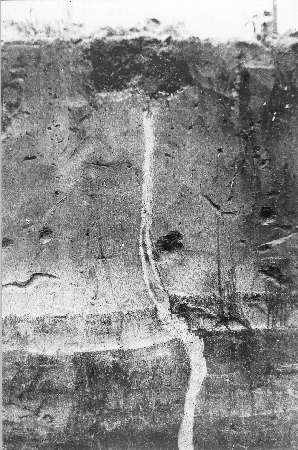
Earthquake fissure filled with intruded sand, formed at the time of the New Madrid earthquake. Mississippi County, Missouri, 1904.
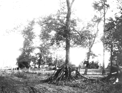
Trees with double sets of roots. Elevated trees left by scooping out of sand by overflowing Mississippi waters south end of Reelfoot Lake. The surface is now about at its original level and the original tree trunk can be seen continuing down to the level of the ground. later the tree was buried by sand to a depth of 5 feet and new roots formed. Still later the sand was removed. New Madrid earthquake. Lake County, Tennessee. 1904.
*"The area of strong shaking associated with these shocks is two to three times larger than that of the 1964 Alaska earthquake and 10 times larger than that of the 1906 San Francisco earthquake."
*"The first earthquake caused only slight damage to man-made structures, mainly because of the sparse population in the epicentral area. The extent of the area that experienced damaging earth motion is estimated to be 600,000 square kilometers. However, shaking strong enough to alarm the general population occurred over an area of 2.5 million square kilometers."
*At the onset of the earthquake the ground rose and fell - bending the trees until their branches intertwined and opening deep cracks in the ground. Landslides swept down the steeper bluffs and hillsides; large areas of land were uplifted; and still larger areas sank and were covered with water that emerged through fissures or craterlets. Huge waves on the Mississippi River overwhelmed many boats and washed others high on the shore. High banks caved and collapsed into the river; sand bars and points of islands gave way; whole islands disappeared. Surface rupturing did not occur, however. The region most seriously affected was characterized by raised or sunken lands, fissures, sinks, sand blows, and large landslides that covered an area of 78,000 - 129,000 square kilometers, extending from Cairo, Illinois, to Memphis, Tennessee, and from Crowleys Ridge to Chickasaw Bluffs, Tennessee.
Although the motion during the first shock was violent at New Madrid, Missouri, it was not as heavy and destructive as that caused by two aftershocks about 6 hours later. Only one life was lost in falling buildings at New Madrid, but chimneys were toppled and log cabins were thrown down as far distant as Cincinnati, Ohio; St. Louis, Missouri; and in many places in Kentucky, Missouri, and Tennessee.
*A notable area of subsidence is Reelfoot Lake in Tennessee, just east of Tiptonville dome. Subsidence there ranged from 1.5 to 6 meters, although larger amounts were reported. It may be that the lake was enlarged by compaction, upwarping, and subsidence occurring simultaneously during the New Madrid earthquakes.
Other areas subsided by as much as 5 meters, although 1.5 to 2.5 meters was more common. Lake St. Francis, in eastern Arkansas, which was formed by subsidence, is 64 kilometers long by 1 kilometer wide. Coal and sand were ejected from fissures in the swamp land adjacent to the St. Francis River, and the water level is reported to have risen there by 8 to 9 meters.
Large waves were generated on the Mississippi River by fissures opening and closing below the surface. Local uplifts of the ground and water waves moving upstream gave the illusion that the river was flowing upstream. Ponds of water also were agitated noticeably."
*The third principal shock of the 1811-1812 sequence was January 23, 1812-The first earthquake of this series on December 16, 1811, was located in northeast Arkansas. It is difficult to assign intensities to the principal shocks that occurred after 1811 because many of the published accounts describe the cumulative effects of all the earthquakes. Using the December 16 earthquake as a standard, however, a comparison between it and the shock on January 23 indicates that the intensities were about equal at similar locations. The meizoseismal area was characterized by general ground warping, ejections, fissuring, severe landslides, and caving of stream banks.
*The fourth and largest earthquake of the 1811-1812 series of quakes: Several destructive shocks occurred on February 7, the last of which equaled or surpassed the magnitude of any previous event. The town of New Madrid was destroyed. At St. Louis, many houses were damaged severely and their chimneys were thrown down. The meizoseismal area was characterized by general ground warping, ejections, fissuring, severe landslides, and caving of stream banks.
The modern city of Memphis, Tennessee, is built on a high bluff overlooking the Mississippi River. During the New Madrid earthquakes of 1811-12, many landslides occurred along the river. The most devastating effects of the shocks, however, were on the Mississippi itself, where river traffic and commerce were disrupted and boatmen were killed.
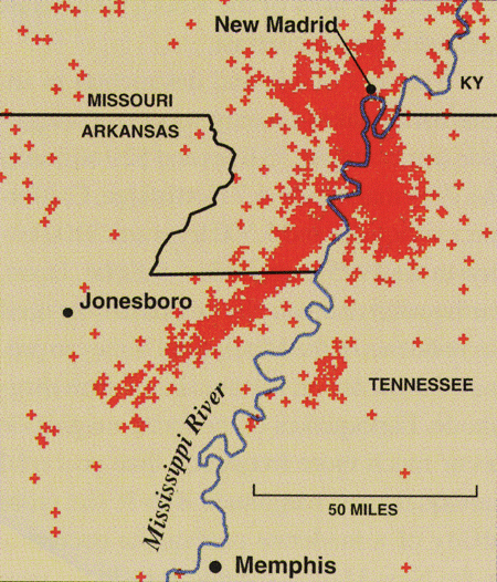
The central Mississippi Valley is the most earthquake-prone region of the United States east of the Rocky Mountains. Crosses show the locations of the many earthquakes recorded in the New Madrid seismic zone since 1974.
The great earthquakes of 1811-12 were not freak events. In recent decades, earth scientists have collected evidence that strong earthquakes in the central Mississippi Valley have occurred repeatedly in the geologic past. Small earthquakes happen in the region frequently.
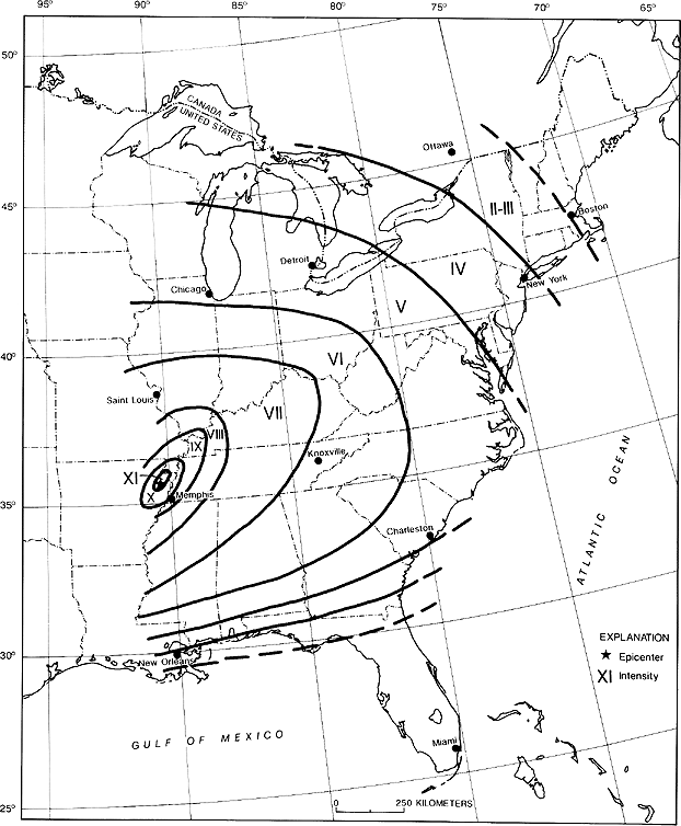
Isoseismal map for the Arkansas earthquake of December 16,1811
- *Photos from the Earth Science Photographs from the U.S. Geological Survey Library, by Joseph K. McGregor and Carl Abston, U.S. Geological Survey Digital Data Series DDS-21, 1995.
- *Abridged from Seismicity of the United States, 1568-1989 (Revised), by Carl W. Stover and Jerry L. Coffman, U.S. Geological Survey Professional Paper 1527, United States Government Printing Office, Washington: 1993.
- USGS-authored or produced data and information are in the public domain.
