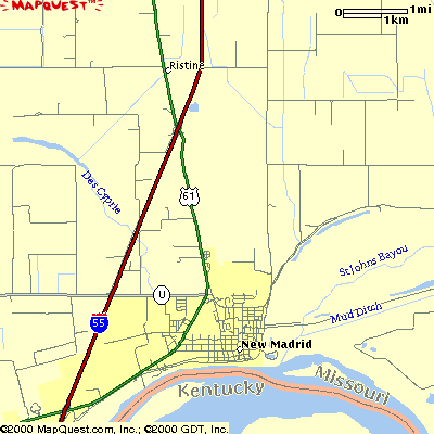
Places in New Madrid County, Missouri, USA.
New Madrid: in New Madrid County, Missouri, USA.

New Madrid
Chamber of Commerce
560 Mott St
New Madrid, MO
63869
Phone: 573-380-3409
Email: info@newmadridchamber.com
New Madrid was incorporated in 1808; in 1811 it contained only two stores
and a few houses; many of the inhabitants of the town moved away after the
earthquake, and for several years affairs were at a standstill.
In 1822
it was selected as the seat of justice. In 1834 and again in 1868, the town
was incorporated by the county court .
The early merchants were: Robert
G. Watson, Robert McCoy, Matteo Boglilolo and George G. Alford.
In 1878
the town was incorporated as a town of the second class ... Just south of
the town is a great Indian mound (1912) which local tradition says is the
site of De Soto's camp. The site is not that of the original town, as that
has long since been swept away by the river. (--Hist. of Southeast Mo.,
1912, Douglas, Vol. 1, pp. 265, 266.)
The county seat was settled in 1780.
Such have been the encroachments
of the river at this point, that the place upon which the original town was
laid off is now one and a half miles from its present site, being half a
mile on the other side of the Mississippi River in Kentucky.
It contained
3 churches
Catholic, Presbyterian and Methodist, 1 public and 2 private
schools, 1 academy, 2 steam saw and grist mills, 2 steam cotton-gins and
presses, a number of shops, about 20 stores, also several warehouses and a
commodious wharf-boat for the storage and shipment of grains and cotton.
At the beginning of the Civil War, New Madrid was a military point of
some importance, and in connection with Island No., 10, acquired much
celebrity. Population about 700 (1874).
(--Gazetteer of Mo., p. 398;
Encyclopedia of the Hist. of Mo., 1901, Conrad, Vol. 4, p. 554.)
It is located at Sec. undetermined, Twp. 23 N, R. 14 E, at the junction of Highways 61 & U.
Historical Sites: include; Hunter-Dawson State Historic Site, Higgerson School Historical Site, and New Madrid Historical Museum.
New Madrid , city (1990 pop. 3,350), New Madrid co., extreme SE Mo., on
Mississippi R. and protected by high levees, and 35 mi/56 km SW of Cairo
(Ill.); 36°35'N 89°32'W.
Cotton, wood prods.; mfg. (aluminum processing;
telecommunications shelters); river port.
Laid out 1789 when under Span.
rule. In Civil War, Federal troops captured city before taking (1862) nearby
Isl. No. 10 in the Mississippi R.; isl., then Tenn. territory, has since
vanished.
The name has been given to the fault zone that runs SW to NE
through several states.
It and its branch faults have been the origin of
numerous earthquakes, most notably the extremely high-energy quakes of 1811
and 1812.
They reversed flow of Mississippi R., created Reelfort L. in
Tenn., rang church bells in Boston, and were felt in Canada and Charleston
(S.C.).
NOTE: Original townsite is in the Mississippi R. channel.